
An update on excavations north of Houghton Regis
Albion Archaeology are pleased to have been involved in significant archaeological investigations in the area under development to the north of Houghton Regis, Bedfordshire. The adjacent chalk ridgelines of the Chilterns have long been known to contain evidence for early prehistoric settlement and ritual activity, but until recently our understanding of past land-use and settlement in the vicinity of HRN1 was based largely on surface artefact collection and small-scale excavations undertaken by The Manshead Archaeological Society. Since 2014, however, large-scale excavations, many carried out by Albion Archaeology, have dramatically expanded our understanding of the area.

Areas of published archaeological investigation to the north of Houghton Regis

One of the large Mesolithic pits. The bones of an aurochs (an extinct form of cattle) recovered from this pit were radiocarbon dated to the 7th millennium BC . The red and white scale is 1m long.
The earliest evidence for human activity (within HRN3486) comprised at least 12 large pits that were radiocarbon-dated to the late Mesolithic. Their discovery was unexpected and is highly significant, given the rarity of features of this period – they represent the largest group of late Mesolithic large pits found to date in England. They were dug, presumably deliberately, adjacent to palaeochannels, which may have been created by seasonal springs or run-off from the higher ground near the source of the Ouzel Brook. Such a location would probably have been highly significant to the hunter-gatherer communities in the area. The pits became the focus for repeated returns and interventions (i.e. filling and recutting) over hundreds and possibly thousands of years. It is interesting that the only early Neolithic pits – much smaller in size – so far identified within HRN1 were also located in this area.

One of two ring-ditch monuments excavated. The earlier, inner ditch was entirely enclosed by the later outer ditch. The red and white scale (centre) is 1m long.
Two ring ditch monuments, presumed to date to the late Neolithic/early Bronze Age were uncovered by the excavations. The two monuments were remarkably similar to each other, though relatively unusual generally - they both comprised an earlier, smaller ring-ditch, which was completely encircled by a later ring-ditch. In one case, the earlier ring ditch was subsequently buried under an associated mound.
All the investigation areas produced evidence for far more extensive activity in the middle Bronze Age to the early Iron Age. It took the form of field/enclosure systems, activity foci (usually indicated by clusters of small pits but also by occasional post-built structures), extensive boundaries (including segmented ditches), post alignments, and a single isolated inhumation. The dating evidence was often limited to a small amount of fairly undiagnostic pottery and a small number of radiocarbon dates. However, there is sufficient evidence to suggest that much of this activity originated in the middle Bronze Age, a period characterised by both an increasing population and societal change.
The late Iron Age/early Roman period also sees extensive evidence for activity, including farmsteads and a small cremation cemetery (comprising 13 graves) which was deliberately located adjacent to a trackway; it was associated with an (unexcavated) farmstead to the south.
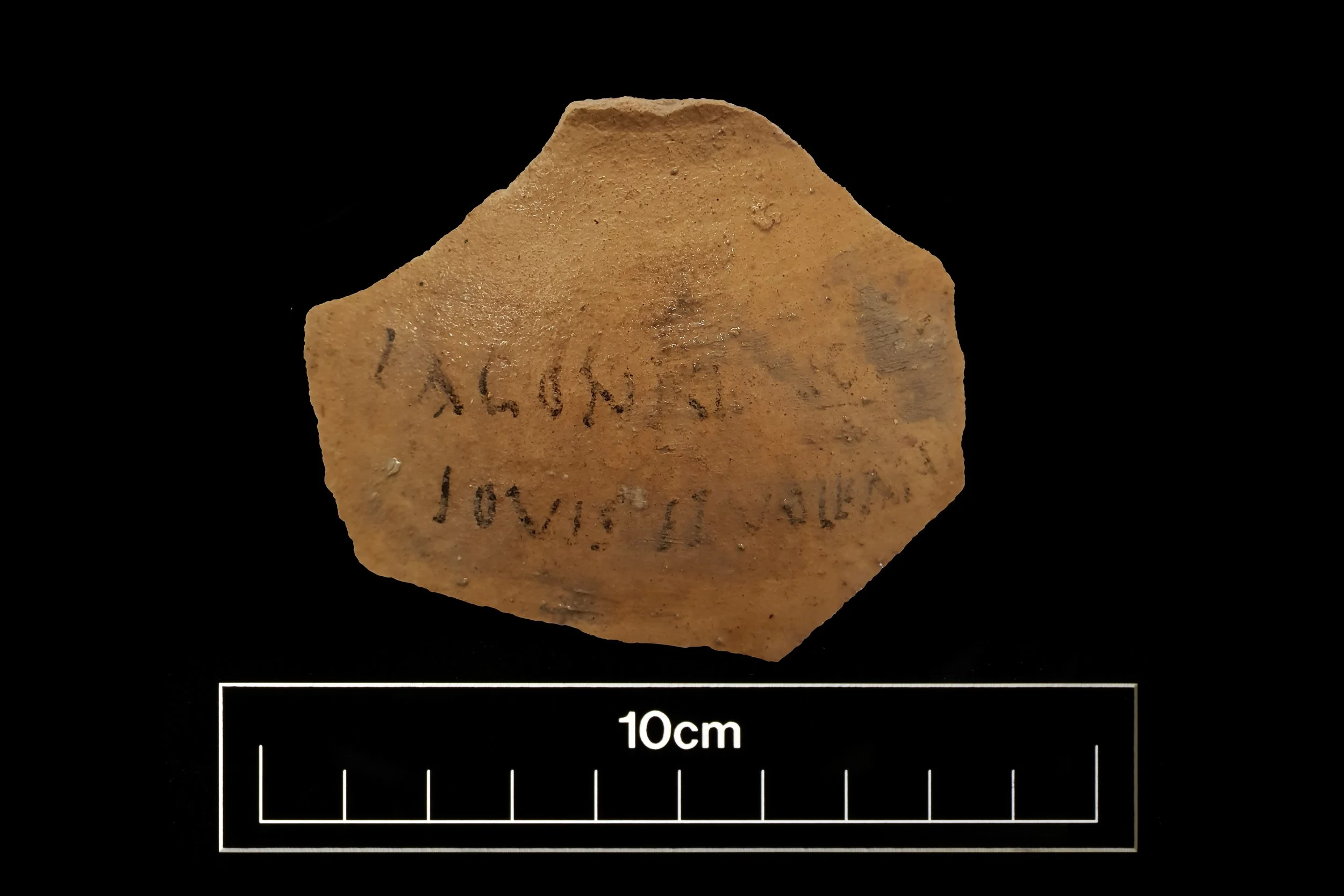
Ink-graffitied pottery sherd. The inscription on this unusual find has been translated by Roger Tomlin as: ‘For a flagon of the gods Jupiter and Vulcan’. There is other evidence from elsewhere in Roman Britain for the cults of these two deities being combined.
Three Roman settlements are known within the area, though only one has been subject to extensive investigation. The largest, extending over c.5.5ha, straddles the Ouzel Brook and has been investigated by geophysical survey, trial trenching and a narrow service trench that traversed it. From this largest settlement, a graffiti-covered sherd of pottery was recovered.
A second settlement, around 2ha in size was established in the mid–late 1st century AD. Deliberate planning is clear in the farmstead’s original layout, with a trackway and adjacent enclosures to the north and south. The pottery and coin assemblages suggest that occupation continued to the end of the 4th century and probably into the early 5th century. Evidence for domestic activity was identified. Of note is the possible evidence for two roundhouses, up to 13 rectangular buildings, and up to four different types of drying oven. Although the finds assemblage was large, including 92 coins, it is comparable to other farmsteads excavated elsewhere in Bedfordshire. However, a small number of the objects stand out from the normal profile one might expect on a rural farmstead, e.g. those associated with the military, with literacy, and with religion, in particular a small stone sculpture.

Roman drying ovens (centre) and a Roman millstone (right), from the Woodside Link excavations. The red and white scale is 1m long.
The third settlement lies to the south and has only been subject to limited excavation. However, its northern environs have been investigated, revealing two trackways, next to one of which were three crop-processing areas, comprising five drying ovens (two of which were extremely well-preserved), a crop-processing building and a plank-lined pit.
The only firm evidence for early Anglo-Saxon activity were two isolated sunken-featured buildings. Their presence reflects a wider pattern of small-scale and dispersed occupation, often in the vicinity of sites that were in use in the Roman period, with the main contemporary settlements probably underlying modern Houghton Regis and nearby villages.
For further information, please see our monograph series. Monograph 7: A Roman Farmstead and Other Late Neolithic to Post-medieval Land-Use at Houghton Regis, Bedfordshire and the newly published Monograph 11: Late Mesolithic to Early Anglo-Saxon Land-Use at Houghton Regis North, Bedfordshire.
References:
Brown, J., 2020 Farmsteads and Funerary Sites: The M1 Junction 12 Improvements and the A5–M1 Link Road Central Bedfordshire: Archaeological Investigations Prior to Construction 2011 & 2015–16. Oxford: Archaeopress Archaeology